This article is available in three languages, so make sure to choose your preferred language on the right.
2024 is a lustrum (five-year anniversary) year for me. And I’m not talking about the 70th birthday of my favourite car and guitar. No, this year it’s
- 30 years since I got my first job
- 25 years since I started studying Geodesy at the University of Stuttgart
- 20 years since I graduated as Diplom-Ingenieur and started as PhD student at the Delft University of Technology
- 15 years since I successfully defended my PhD thesis and left the academic world to pursue a career in the real world
- 10 years since I left the security of a large company to become part of a small start-up, a move that would eventually lead to where I’m now professionally
So lots of anniversaries, with the 25 years of Geodesy being the one that most defined my future. A good opportunity to look back 25 years, and to look ahead as well.
Geodesy and surveying 25 years ago
The turn of the century was an exciting time for geodesy and surveying. Several technical developments reached maturity, profoundly transforming the world of surveying and mapping.
GPS is coming of age
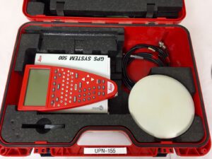
GPS has a long history dating back to the 1970s. A limited constellation was used by US forces in the First Gulf War in 1992, and surveying use began around this time as well, but remained far from mainstream in the 1990s. During my internship at the Cadastre of Baden-Württemberg in 2000, there was a single RTK-GPS set for the entire state. As no commercial reference systems existed yet, doing RTK-GPS work required two receivers with a radio link. In the case of the Leica System 500 GPS that we used at the university, a single receiver consisted of an antenna, a control unit with display and buttons, and the receiver itself, which was usually carried in a backpack as it was quite large and heavy.
A pivotal moment for the civilian use of GPS was the shutdown of Selective Availability in 2000, which brought accuracy to about 1m, enabling GPS-based car navigation. For surveying use, the breakthrough came with smaller and cheaper fully integrated receivers and the availability of countrywide reference networks to which the receiver could connect via GSM modem, removing the need for two receivers for RTK surveying.
GPS and its competitors have had a major impact on surveying and geodesy, not always in a positive manner. It has given us the capability to do accurate surveys over long distances that were simply impossible before, but the availability of an accurate coordinate at the push of a button has also led to a dumbing down of surveying, with knowledge of geodetic principles less important than in the past.
Rise of the robotic total station
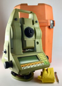
The introduction of the total station in the 1970s, a combination of a theodolite with an electronic distance measurement device, revolutionized surveying. Suddenly it was possible to obtain 3D coordinates with a single measurement. The next evolution came with motorised robotic total stations that could autonomously find and measure prisms. This enabled automatic monitoring and even tracking of moving prisms, though the Leica TCA1800 and TCA2003 total stations that we used at the university where so slow to move that it was next to impossible to do productive work in this way. This changed with the introduction of the Leica TPS1200 and Trimble S6 total stations, which were much faster (especially the Trimble) and came with integrated radios. Where during my internship a survey team consisted of two or even three persons, a few years later the solo surveyor was the norm, equipped with a robotic total station and GPS receiver.
Another development during this time was the introduction of total stations that could do reflectorless measurements without a prism, a feature that is now standard. Today’s total stations are still very similar to those introduced 20 years ago.
Digital photography makes its entry
My first contact with digital photography was in 1999, when one of my platoon mates bought a very expensive Canon digital camera that probably had a resolution of 1.3 megapixels. Throughout my studies, film cameras where still the norm for airborne photography and photogrammetry, as creating cameras with the resolution required for airborne use proved to be a challenge. The two main competitors at the time where the Z/I Imaging DMC and the Leica ADS40. The former employed multiple rectangular sensors, the latter line cameras. The DMC concept proved to be the one that is still used today, though Z/I Imaging no longer exists.
Digital photogrammetry has had a huge impact. In the film era, you needed to buy expensive film, develop it, then scan it for further digital processing. With digital cameras, all intermediate steps were removed and photography essentially became free save for the cost of getting the camera airborne and processing the data. Photogrammetry is now ubiquitous in surveying, whether from airplanes, drones, cars, or even handheld for detailed surveys of things like building heritage.
Here comes the laser scanner
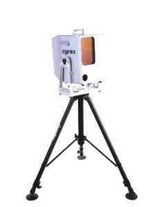
Like GPS and total stations, the beginnings of the laser scanner date back to the 1970s, but widespread adoption took much longer. We got our first demonstration at the university in 2003. Leica had just acquired Cyra Technologies, and their scanner was, compared to today’s scanners, very slow with a narrow field of view. Processing the data with Cyclone (still the name used by Leica used for its scanning software) was slow and required lots of manual work, and I earned a bit of ridicule when I claimed that it was necessary to automate this. Oh how far we have come in 20 years… While laser scanners are still expensive, laser scanning has now become nearly as ubiquitous as the other surveying techniques mentioned here, thanks to advances in both hardware and software.
Looking forward
Looking back is nice for nostalgic reasons, but what does the future hold for us geodesists? Here are some things that I could come up with.
The 3Dfication of everything
I mentioned that a total station could provide 3D coordinates, but at least in cadastral work, this was seldomly used. 2D and height were separate things, in some cases quite literally so. In the Netherlands, the 2D coordinate system is maintained by Kadaster whereas the height reference system is maintained by Rijkswaterstaat. Even an intrinsically 3D survey method like GPS is used often only to obtain planar coordinates.
Thankfully, in recent years the additional benefits of 3D are becoming obvious. This is at least partly fuelled by advances in software. Game engines and techniques like WebGL have made it easier to visualize and use 3D data. Combined with laser scanning and photogrammetry as surveying techniques, I’m sure that 3D will only increase in use and importance in the coming years.
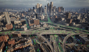
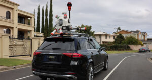
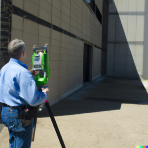
Mobile mapping is everywhere
25 years ago mobile mapping was mostly limited to airborne photogrammetry, as there were no viable mapping and positioning systems for use on a road vehicle. Thanks to affordable GNSS/INS positioning systems, laser scanning, digital photography and techniques like SfM (Structure from Motion) and SLAM (Simultaneous Localization and Mapping), mobile mapping can now be employed at practically any scale from a person “scanning” an object with a smartphone camera, via personal mapping systems that can also be used indoors, drones, vehicles up to manned aircraft. The challenge is not in acquiring the data, but in a) guaranteeing its quality and b) getting useful information out of it. Nevertheless, I expect more traditional point-wise surveying methods to become less important in the future, except in areas with very high accuracy requirements.
Cloud vs. edge computing
Cloud computing, a buzzword 15 years ago, is very common these days, though there certainly is some truth to the statement that the Cloud is simply someone else’s computer. The Cloud offers benefits especially in terms of scalability compared to a traditional on-premise solution. But Cloud computing is not the answer to everything, with the main issues being in my opinion a) the challenge of getting the huge amounts of data acquired by modern mapping systems into the cloud, and b) cost, as Cloud solutions for sustained use are often significantly more expensive than on-premise solutions.
On the other side, we see edge computing, which basically means that sensor data is processed directly on a computer attached to the sensor, thus considerably reducing the amount of data that has to be transferred and processed later on. We’re seeing beginnings of this in Mobile Mapping with e.g. image anonymisation during acquisition, and I feel that this is an important development to deal with ever increasing volumes of data.

AI
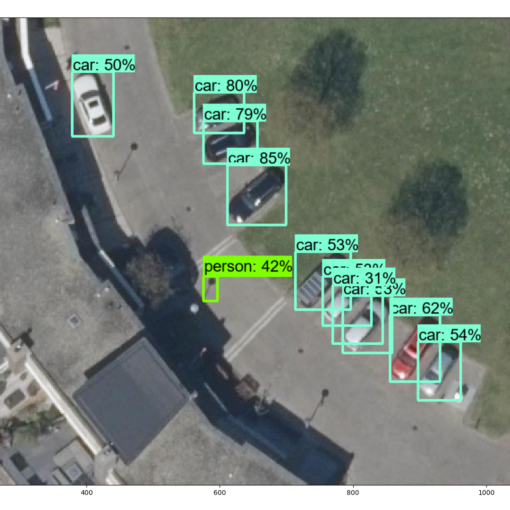
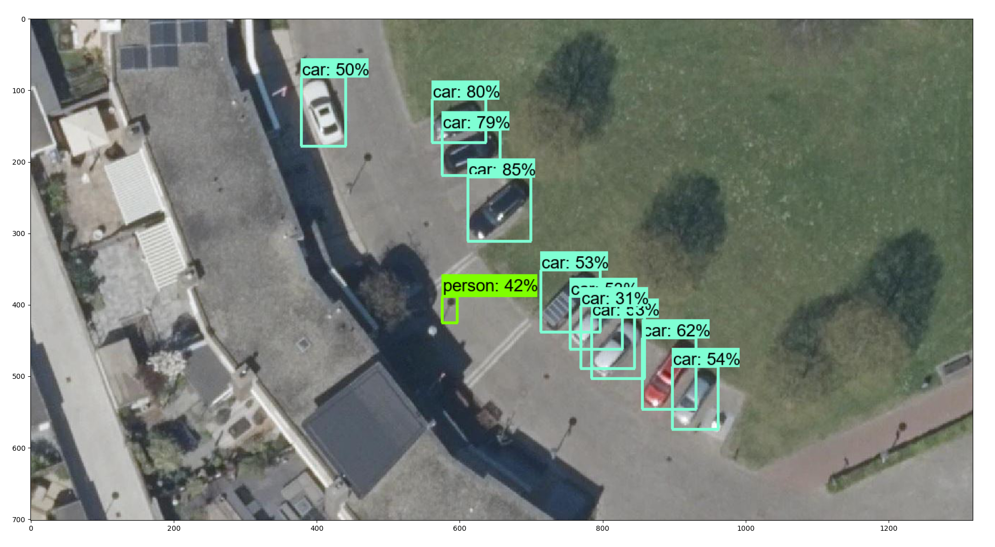
Unless you’ve been under a rock you will have noticed that Artificial Intelligence is the current hotness. Much of the media focus is on Generative AI, i.e. artificial neural networks that can create new things such as text, images, or even video. But AI/Deep Learning and Machine Learning in general have important roles in data processing, whether it’s in point cloud classification, object recognition, or NeRFs (neural radiance fields) that offer a compact description of 3D scenes. Explainability and training bias remain issues though, as is the computational cost associated with AI. The full impact that AI will have is difficult to foresee at this point.
Everything is connected
This holds not only for the four subjects mentioned above, whereby an AI algorithm might use Cloud or Edge computing to process Mobile Mapping data to produce a 3D product, but for everything. Our hardware, our software, indeed our lives are very much connected via networks these days and will not function without. While it is nigh impossible to keep track of everything that is being developed, it’s only the proper combination of all techniques that will offer the most benefit. This is why we need both specialists that can understand ever more complicated systems as well as generalists that can see the bigger picture. I enjoy working in the present, but I’m also glad that I experienced geodesy 25 years ago.
